New Zealand lies on the Pacific Ring of Fire and has several distinct volcanic zones due to the subduction of the Pacific Plate beneath the Australian Plate. The most active zones are on the North Island or offshore; close to it. New Zealand continues to move and shake and continues to surprise visitors and locals alike.
Whether it be above ground; in a liquid or steam form; or underground there is something always happening with vibrancy and excitement.

To experience “raw” Aotearoa (New Zealand) you can dip your feet in to hot water on actual beaches (Hahei on golden sand and Kawhia on Iron sand). You can discover the “right spot” in a river or lake to bathe in ; or leave it to experts and enjoy thermal activities such as spa’s and soap terraces, mud bathes and even hot water water slides!
The Rotorua region is especially a photographers and selfies dream with vibrant colours and explosive action , with the aroma (often referred to as rotten eggs) uncaught by the lens. There truly is something for everyone which each region having a rich history in volcanic activity.
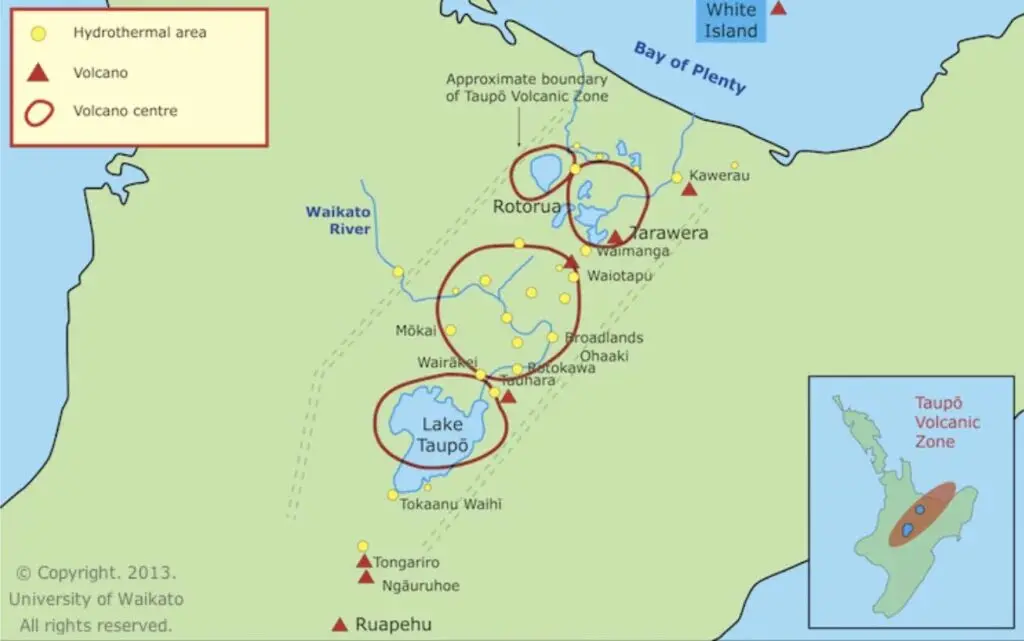
- Location: Central North Island – from Mount Ruapehu to White Island (Whakaari)
- The most famous and active Volcanic Zone within New Zealand covering, Ruapehu, Tongariro, Ngauruhoe, Taupō, Rotorua, Tarawera, through north to White Island
- Eruption History:
- Taupō eruption (~232 CE): One of the world’s most powerful in the last 5,000 years.
- Mount Tarawera (1886): Destroyed the eight wonder of the world ; the Pink and White Terraces, killed ~120 people and buried the village of Te Wairoa. After the eruption in 1900 until 1904 the Waimungu Geyser was for a time the most powerful geyser in the world; erupting up to 1500 ft (460m) high.
- Ruapehu and Tongariro: Frequent small eruptions; Ruapehu erupted in 1995 and 2007.
- White Island (Whakaari): Last deadly eruption in 2019. Now inaccessible to visit on the ground however scenic flights can operate to view the island from the air.
- Home to
- Rotorua: Geothermal parks (Te Puia, Wai-O-Tapu, Hells Gate), geysers, hot springs, mud pools. Affectionally known as RotoVegas or Queenstown of the North Island!
- Tongariro National Park: Tongariro Alpine Crossing – hike past active vents and crater lakes.
- Mt. Ruapehu: Skiing and volcanic crater lake views.
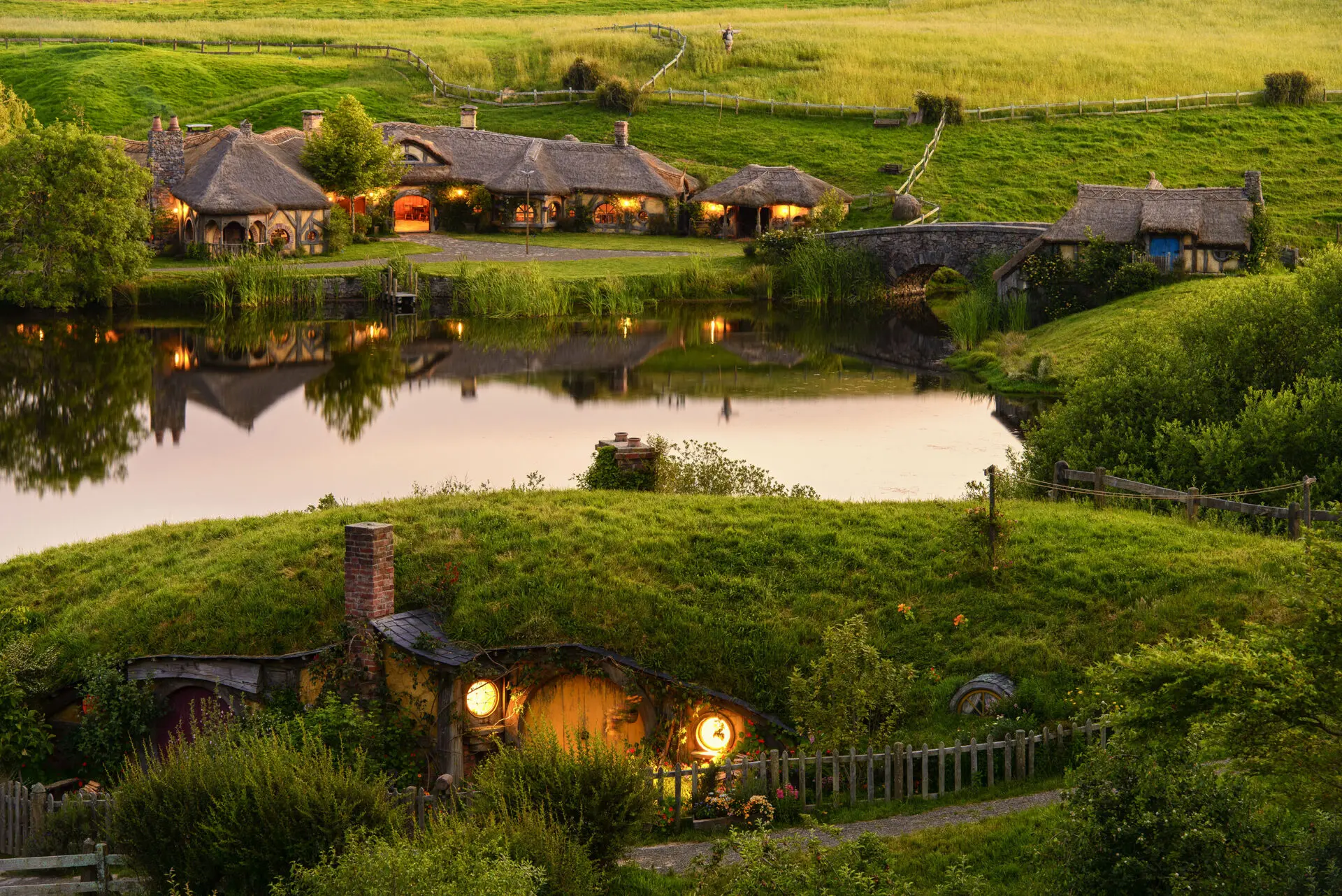
- Mt Ngauruhoe: Known as Mt Doom to Lord of the Rings movie buffs.
- Lake Taupō: Caldera lake formed by massive volcanic explosion. Popular holiday location.
- Orakei Korako and Waimangu Volcanic Valley: Geothermal wonders with silica terraces.
- Location: New Zealand’s most popular city Auckland; and surrounding region
- Volcanoes: Over 50 small basaltic cones (e.g., Rangitoto, Mt Eden, One Tree Hill, Mt Victoria)
- Eruption History:
- Monogenetic field: each volcano erupts once.
- Rangitoto Island: Most recent eruption ~650 years ago, largest in the field. Footprints were found after the eruption on neighbouring Motutapu Island.
- Home to:
- Rangitoto Island: Aucklands youngest Volcano. Accessible by ferry, kayak, hike to summit, lava caves and amazing views.
- Mt Eden (Maungawhau): Closest “Maunga” or Mountain to CBD. City views from crater rim and key Maori pa with food storage pits
- One Tree Hill (Maungakiekie): Cultural and geological significance.
- Mt Victoria (Takarunga): Views north and back to the city in Devonport; the earliest European settlement in Auckland. Just a 10 minute ferry ride from CBD.

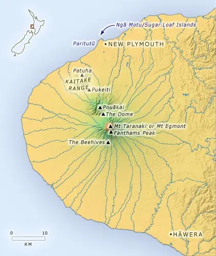
- Location: Western North Island. Main Volcano: Mount Taranaki (Egmont)
- Eruption History:
- Last erupted in the mid-18th century.
- Previous eruptions over the last 7,000 years; considered dormant but not extinct.
- Home to:
- Egmont National Park: Iconic symmetrical volcanic cone, hiking (Pouakai Circuit), climbing, waterfalls, lush forests.
- Egmont National Park: Iconic symmetrical volcanic cone, hiking (Pouakai Circuit), climbing, waterfalls, lush forests.
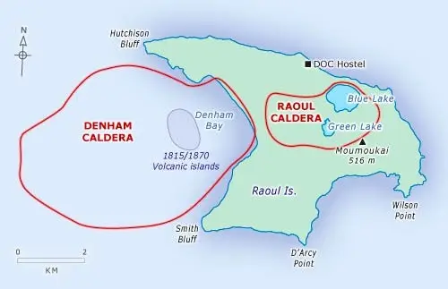
- Location: 1,100 km northeast of New Zealand’s North Island
- Volcanoes: Primarily submarine, but Raoul Island is the largest subaerial volcano in this arc.
- Eruption History:
- Frequent eruptions over the past 1,000 years.
- Last significant eruption: 2006, which tragically killed a Conservation worker.
- Others: Notable eruptions in 1814, 1870, and 1964.
- Home to
- Raoul Island is part of the Kermadec Islands Nature Reserve (access is restricted to scientific or conservation missions requiring a permit and accessible by private boat).
- Snorkeling/diving around the Kermadecs is renowned for marine biodiversity near volcanic vents (via special expeditions).